
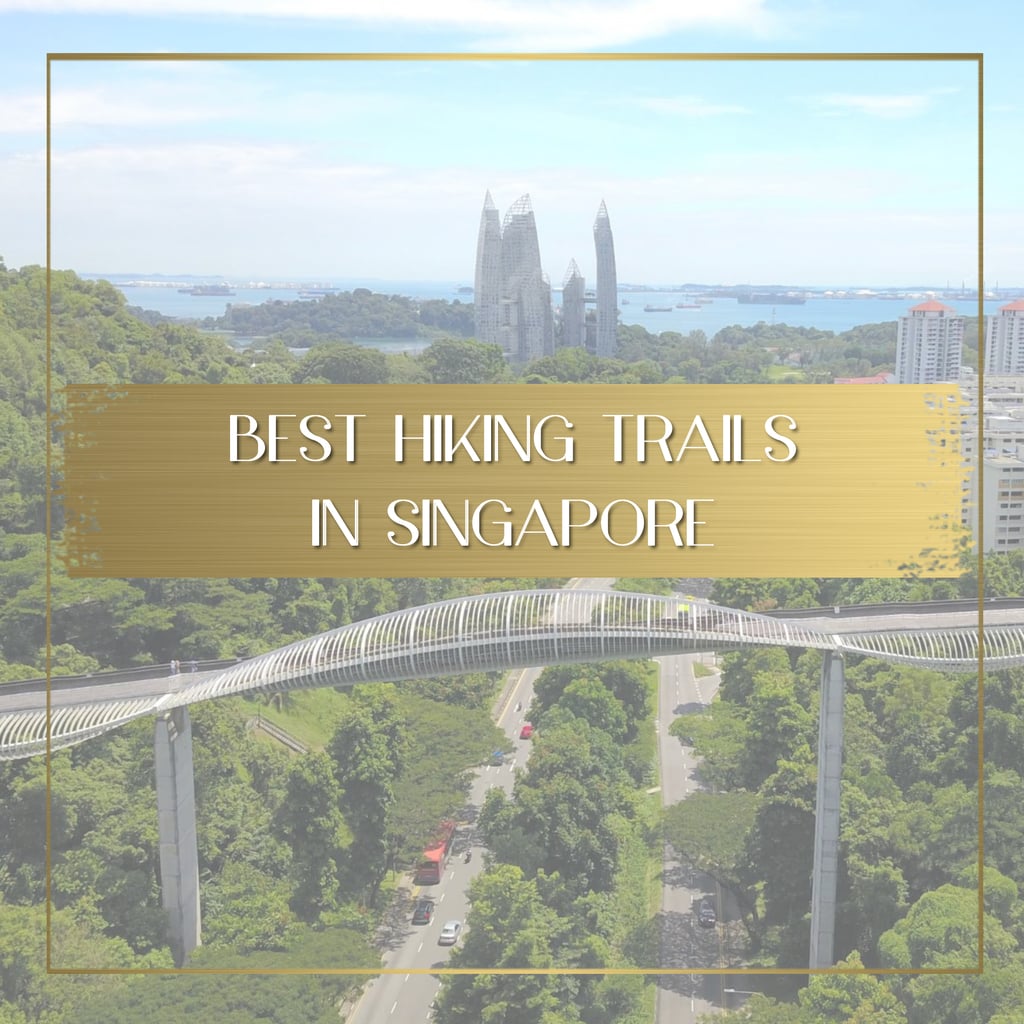

Hiking trails in Singapore can be quite exciting. In the same hike, you can combine coastal trails with forests, canopy walks and boardwalks all while spotting some wildlife (even crocs) and lots of local and tropical flora.
In this article we have put together some cool hiking trails in Singapore that range from easy, flat walks that are more of a leisurely stroll you can do with little kids to longer and more strenuous hikes and even a multi-day hikes (that’s right), although don’t expect an Everest Base Camp teahouse style trek here, it is probably best that you head back home or take a staycation at a luxury hotel every evening.
We have sorted the below list of hikes from shortest to longest.
Changi Point Coastal Trail – 2.2km

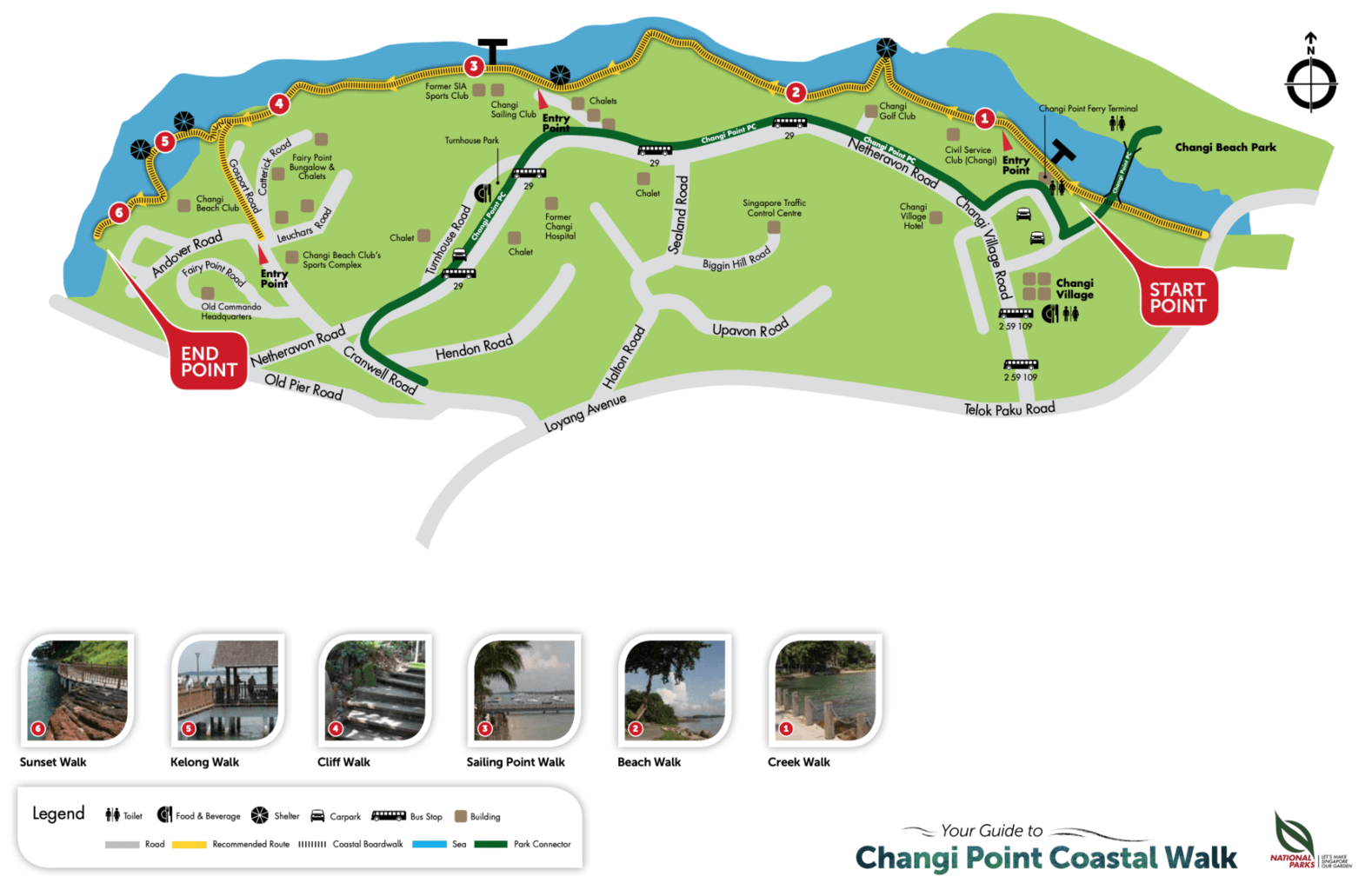
This short and very easy walking trail in Singapore is located in Changi and will take you through vegetation and sea views with a lot of opportunities to spot local flora and fauna and enjoy the coastal breeze on the sea facing path or the overwater boardwalks.
And did we say the trail starts at Changi Village? Great place for a breakfast to kickstart your day or a lunch to end the walk, and don’t miss the chance for a peaceful chillout time under the shade of trees at the Promontory.

Pro tip: Make this a half day Singapore hike by connecting this trail with Changi Beach Park (further down) or returning to the starting point through the park instead of the beach.
St John’s Island Trail – 2.8km

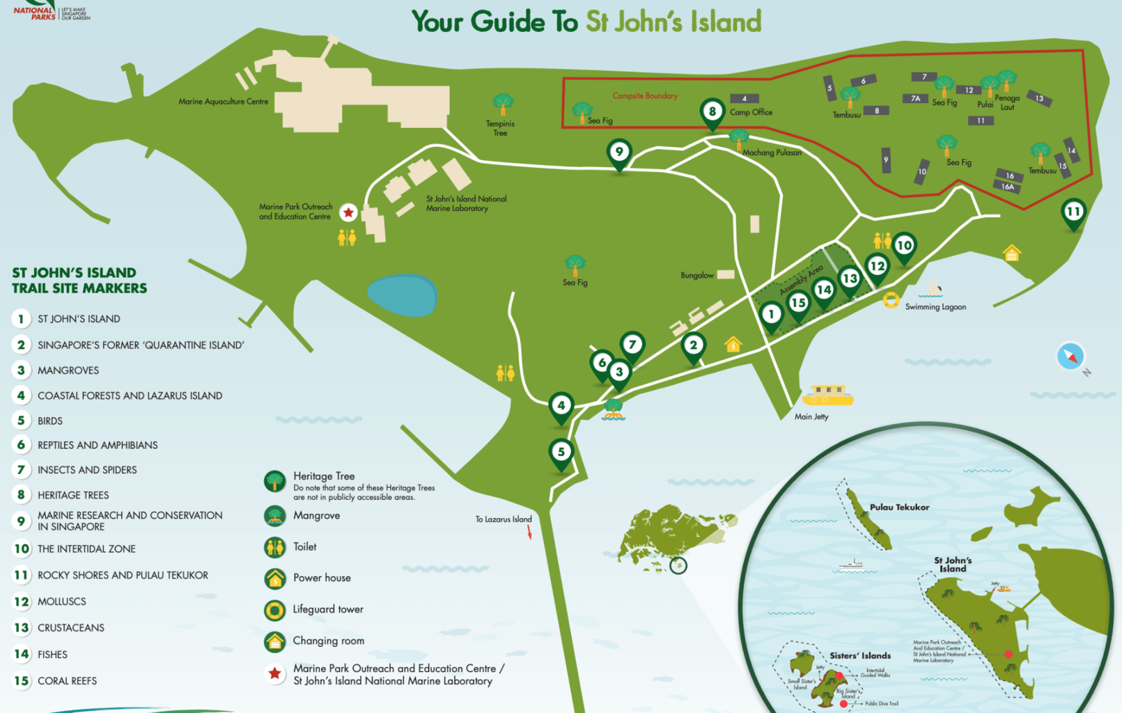
Going offshore for your Singapore hike is always a good idea. Explore St John’s Island, one of the 4 accessible Southern Islands, on a ferry day trip and combine some beach time with some walking. St. John’s is the largest island in the group and so it is the only one which has a real hiking trail marked on the floor with blue and yellow lines.
This is one of the shortest hikes in Singapore that you should be able to complete in just over half an hour and makes for a good break from the Singapore beach time on St. John’s or Lazarus Island.
Along the way, look out for the panels with explanations on the history of the island (hint: it used to be a quarantine island well before COVID), the vegetation found and the animals, on land, air and sea. There is quite a lot going on if you pay attention and kids will love it.
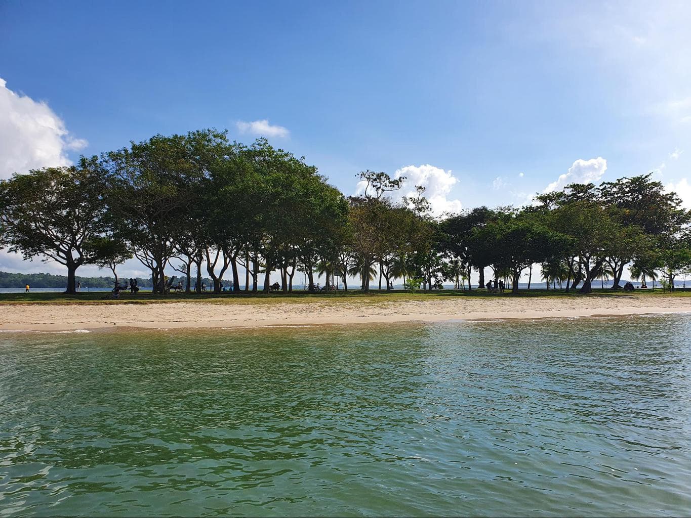
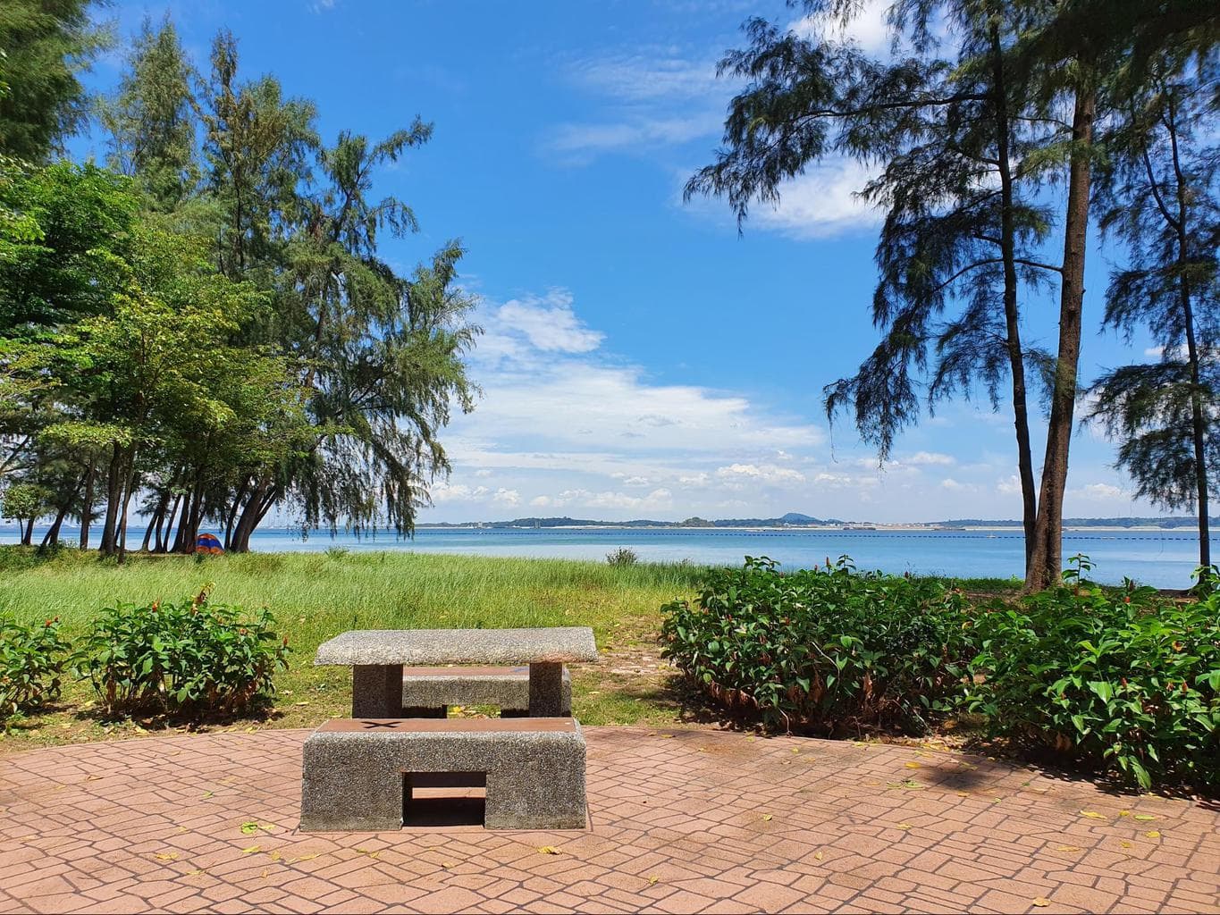
Changi Beach Park – 3.3km

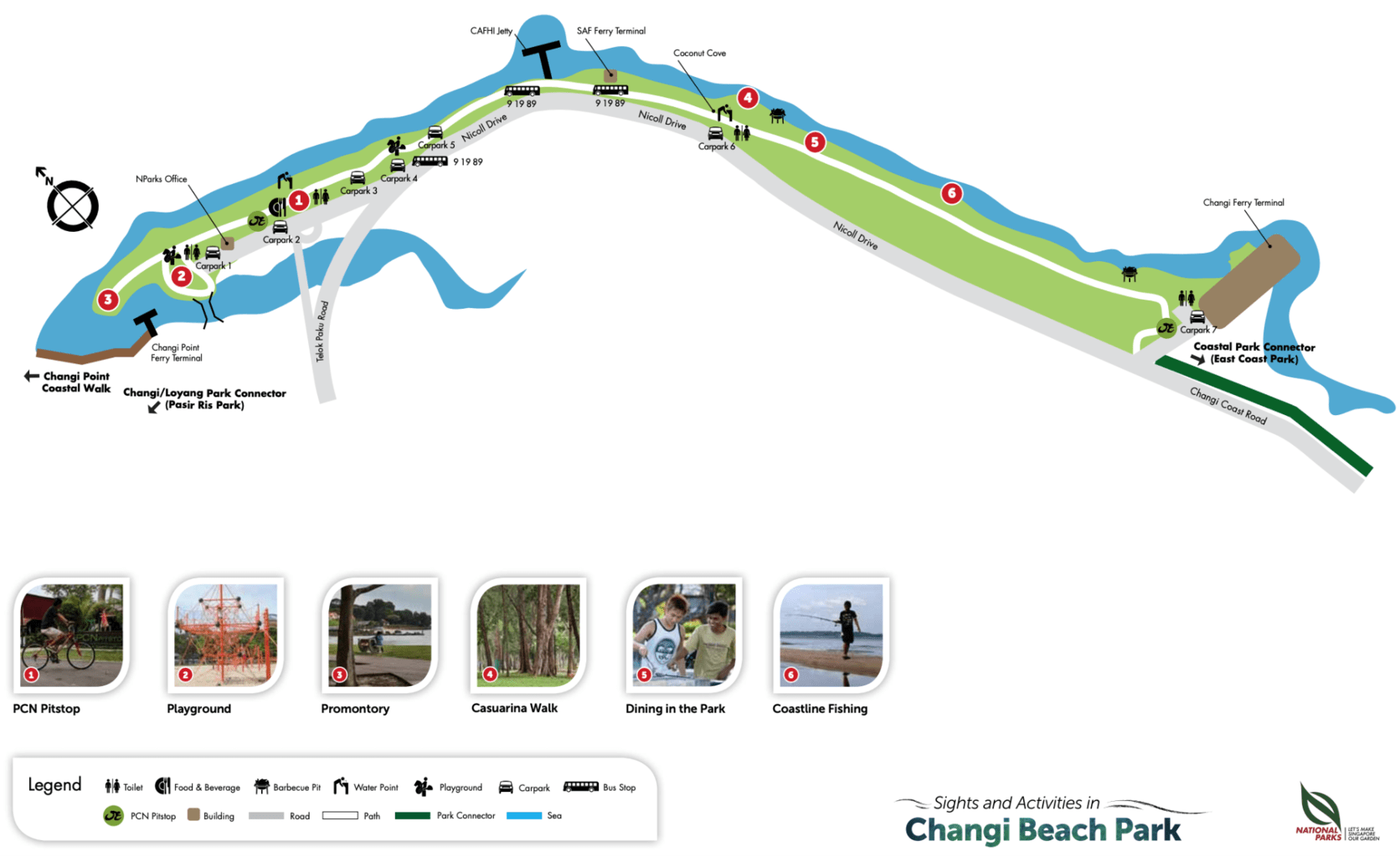
Changi Beach is the longest stretch of pristine beach in Singapore and offers fluffy, empty and usually clean sand and grass for BBQs, picnics, camping, fishing, sun tanning, sand castle building and more.
This hike is very pleasant. It is largely shaded (except for the stretch around the SAF ferry terminal), and mostly empty for the first half of it.
Start at the Changi Ferry Terminal entrance, we particularly love this part because you can spot planes landing at Changi Airport right above your head among shaded trees and peaceful fishermen.
Pro tip: Be careful with the beach here because while it looks quite clean, there are often pieces of concrete, broken tiles and even lost fishing hooks or pieces of glass hidden in the sand.
Continue walking towards the Promontory along the path which follows the sea. For the first half of the walk, you will probably have the path all to yourself. Towards Bistro@Changi, it will start to get a bit more popular and you will find more people enjoying picnics and fishing.
MacRitchie Reservoir boardwalk trails – 3km and 4.8km

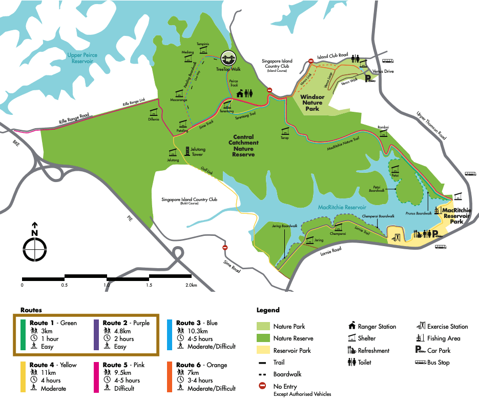
MacRitchie Reservoir is one of our favorite parks in Singapore and this is because it is the largest and it has something for everyone.
We have included MacRitchie twice on this list of hikes in Singapore. In this case we are talking about the Petai and Chemperai trails and later on we will talk about the complete loop.
The Petai boardwalk trail will take around 45min to cover and is a pleasant, really easy but very rewarding 3 km walk. Starting off at the main entrance, you can head up to the start of the boardwalk and simply follow the map.
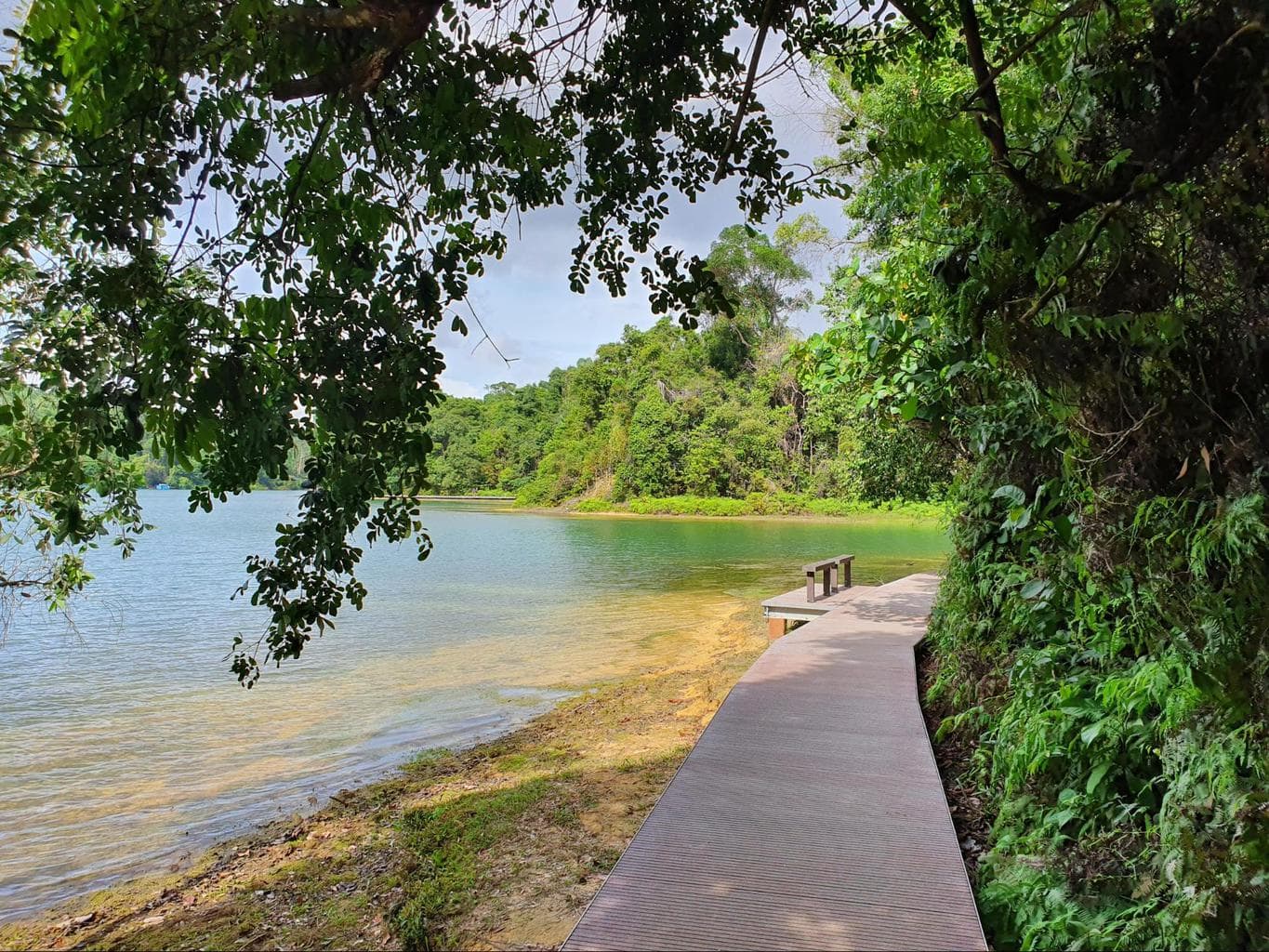
If you are up for it, we also highly recommend taking the other boardwalk which is 4.8km long and is called Chemperai trail. It is also flat and runs on a boardwalk along the water.
In both cases, you will spot all sorts of wildlife, and are almost guaranteed to see monitor lizards and monkeys, turtles are also pretty frequently spotted and lots of fish fill the water. Stop at the many signs explaining the local flora and fauna which are filled with curious fun facts, and bring a sandwich or snack to enjoy at the few benches along the way. The boardwalks are popular but generally peaceful.
Pro tip: Monkeys are really common on the trails and will steal your lunch, do not doubt it, so keep all food and drinks tucked away if you spot them.
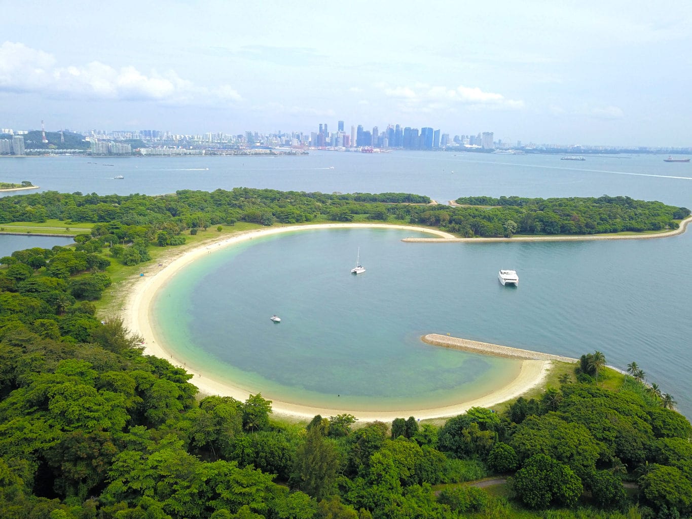
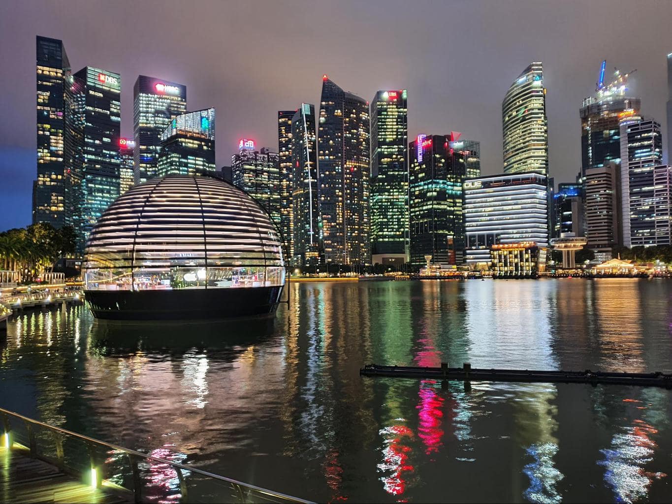
Marina Bay loop – 3.8km

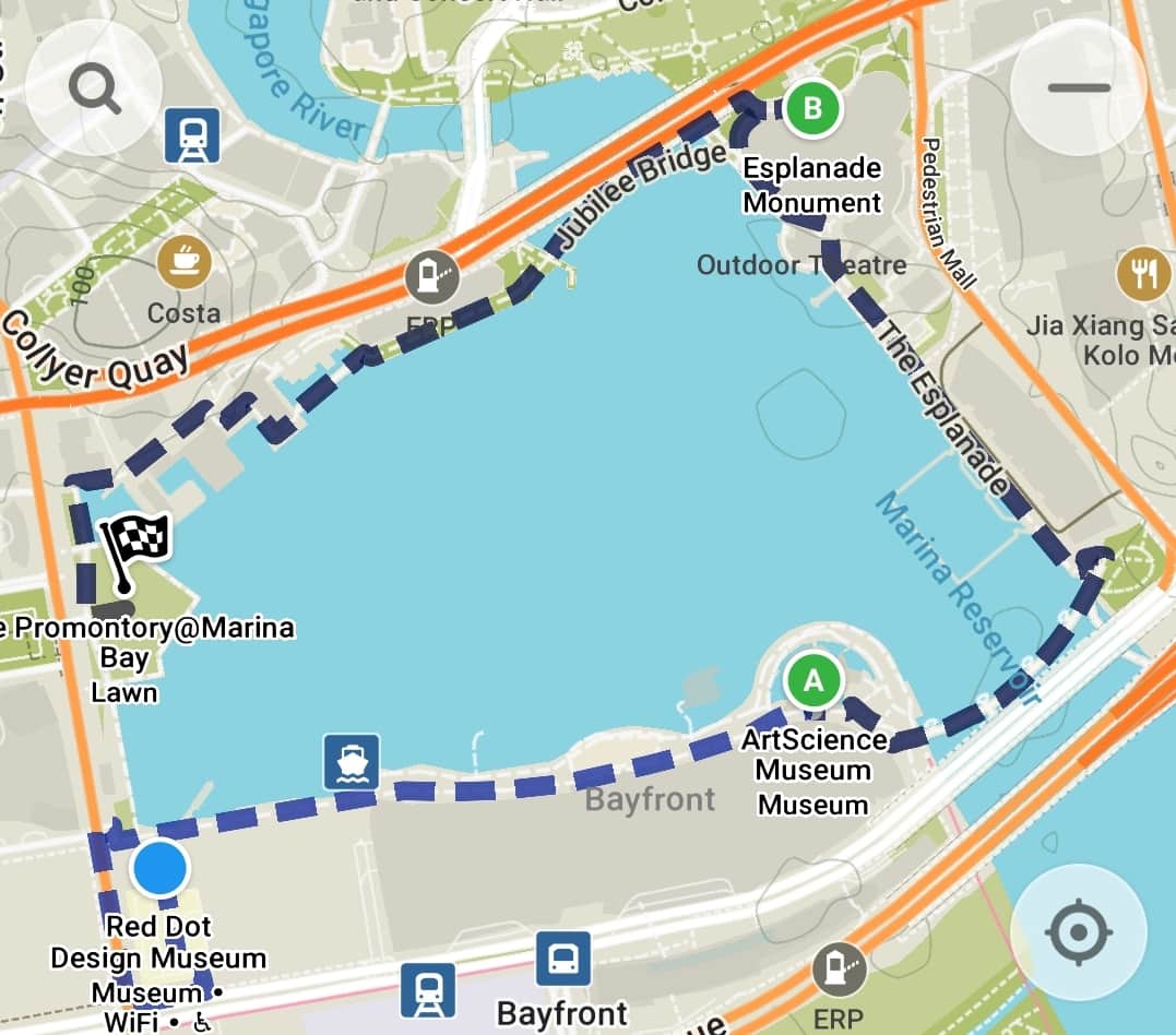
This easy and very scenic walking trail takes in some of the most photographed spots in Singapore and is great day or night.
Start at any point of the Marina Bay and simply follow the water to complete a walk that is just under 4km long and should take about 45min.
Take shots of Marina Bay Sands, ArtScience Museum, the Merlion, the CBD skyscrapers, the Esplanade and the new Apple floating store, you may end up spending longer taking photos than actually walking!
Labrador Nature Reserve – 5km

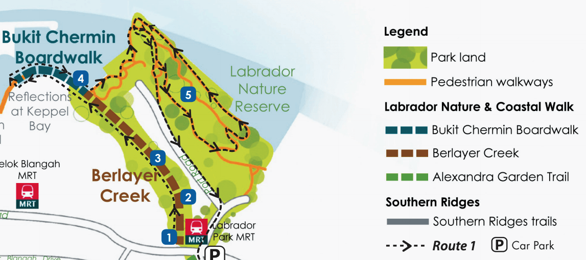
Labrador Park has four distinct areas: the forest area, the coastal area, the mangrove boardwalk in Berlayer Creek and the overwater Bukit Chermin Boardwalk and this hiking trail in Singapore will take you through all of them.
Start off at Labrador Park MRT station and head towards the mangrove area and then follow the boardwalk towards Keppel only to retrace your steps back to the coastal part of the park.
From here, head towards the flat coastal park area all the way to the jetty at the end, and return following the water’s edge. You will then head into the forest to follow the WWII heritage trails with explanation panels, replicas of soldiers and canons.
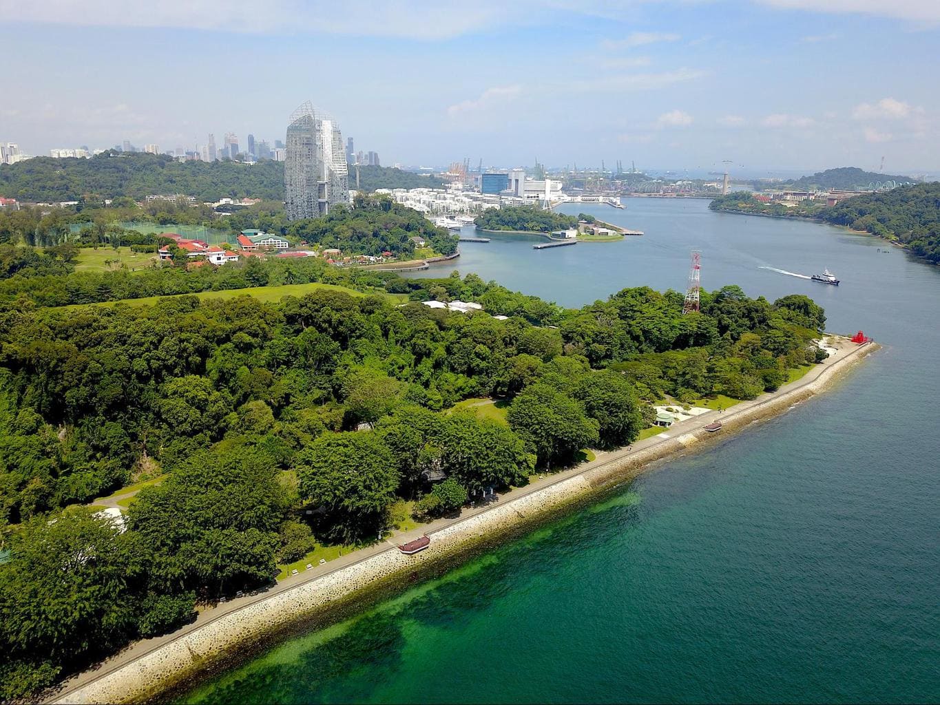
In such a small trail, you can see all sorts of vegetation, fauna and enjoy the seabreeze. Bonus points for being so accessible via an MRT station. You can end the walk at Keppel Marina for brunch or walk towards Harbourfront or VivoCity shopping malls.
You can connect this trail with the Southern Ridges, or with a walk across to Sentosa.
Sungei Buloh – 5km

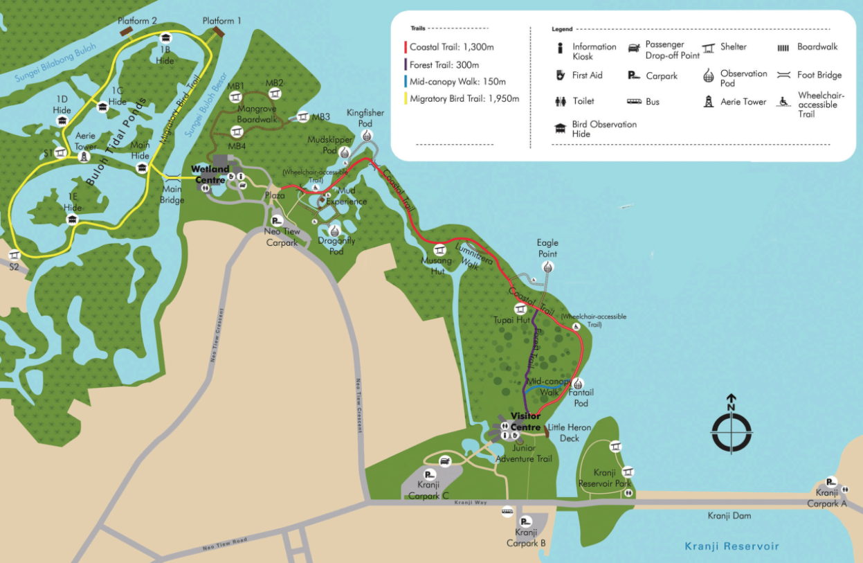
Sungei Buloh is one of our favorite parks in Singapore because of its diversity and the variation in landscapes. And with so much to see in such a relatively small park and walking trail it is great for families with small kids too.
Start at the main visitor center near Kranji Reservoir Park where the little ones can enjoy the adventure trail, then follow the coastal walk all the way to the wetland reserve area. At the wetland reserve you can walk the entire loop looking for wildlife and birds. Don’t miss out on the chance to climb up the watchtower.
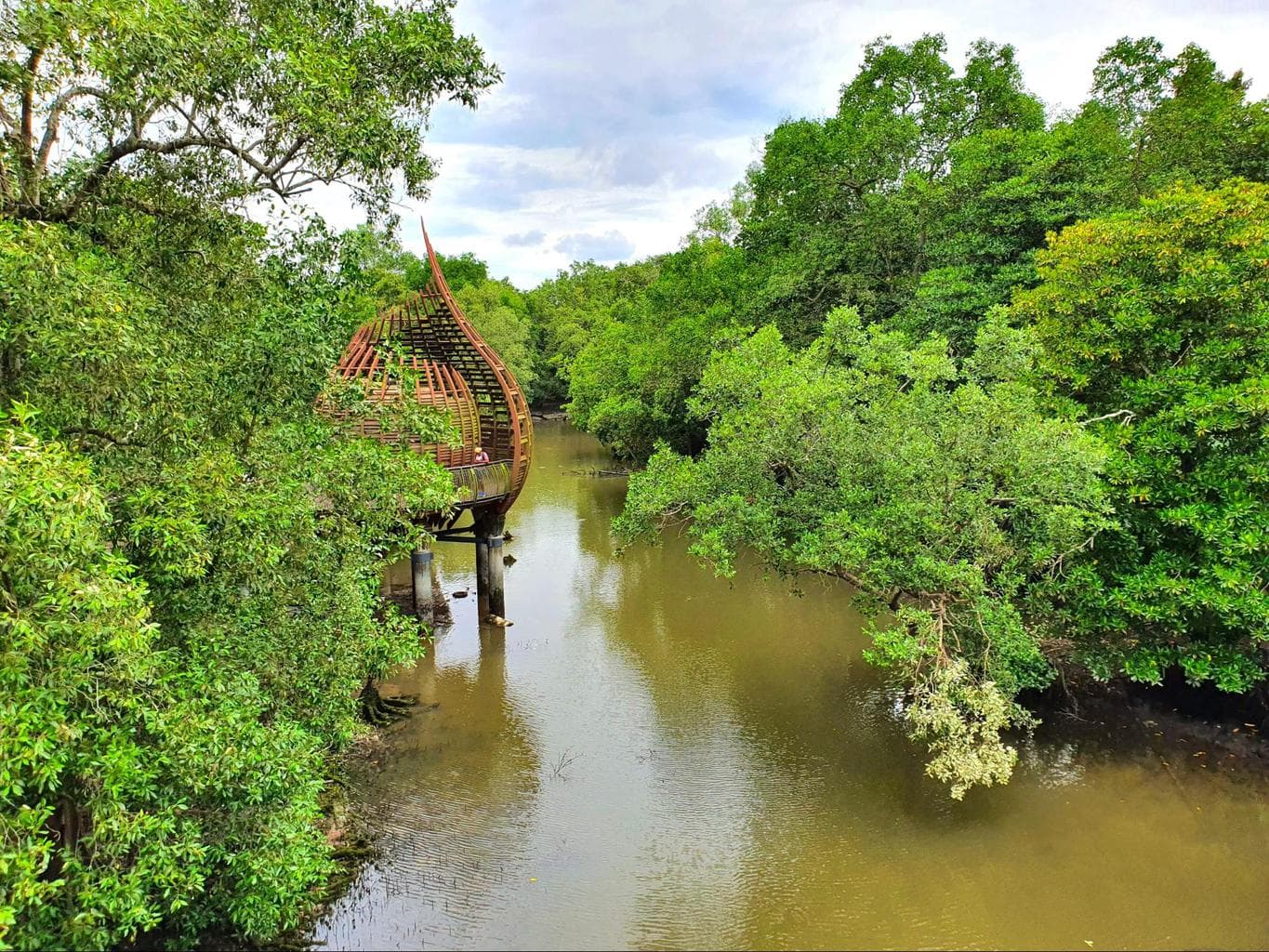
Along the way, spot crocodiles, lots of colorful birds, and all sorts of wildlife who live between the mangroves. Take nice shots at the bird watching shelters and bring binoculars to get up and close with the bird species that call Sungei Buloh home.
Visit the exhibitions at both visitor centers where you can learn more about the mangrove habitats in Singapore, the land reclamation efforts and the diversity of flora and fauna in the country.
Singapore River walk – 5.8km

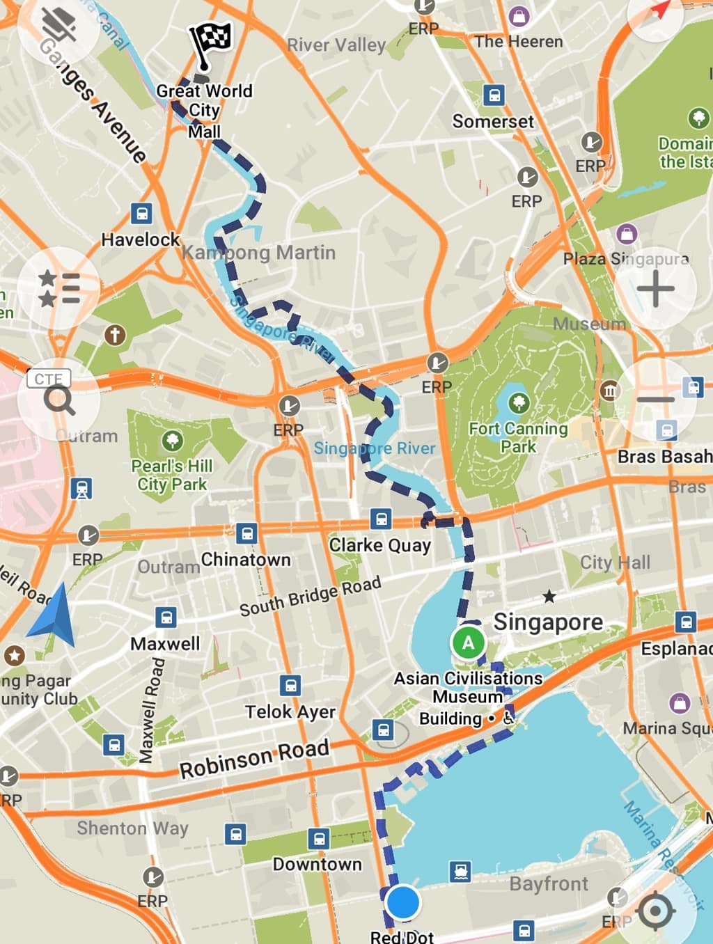
This easy and peaceful walk goes from the Red Dot Museum all the way up to Great World City following the snaking river. You can easily connect this walk with the Marina Bay Loop for a close to 10km walk, or make it a return trail walking up one side of the river and down the other.
Pro tip: This walk is pleasant during the day, though there is not a lot of shade, but it is even better at night when all the lights are on, especially on the bridges.
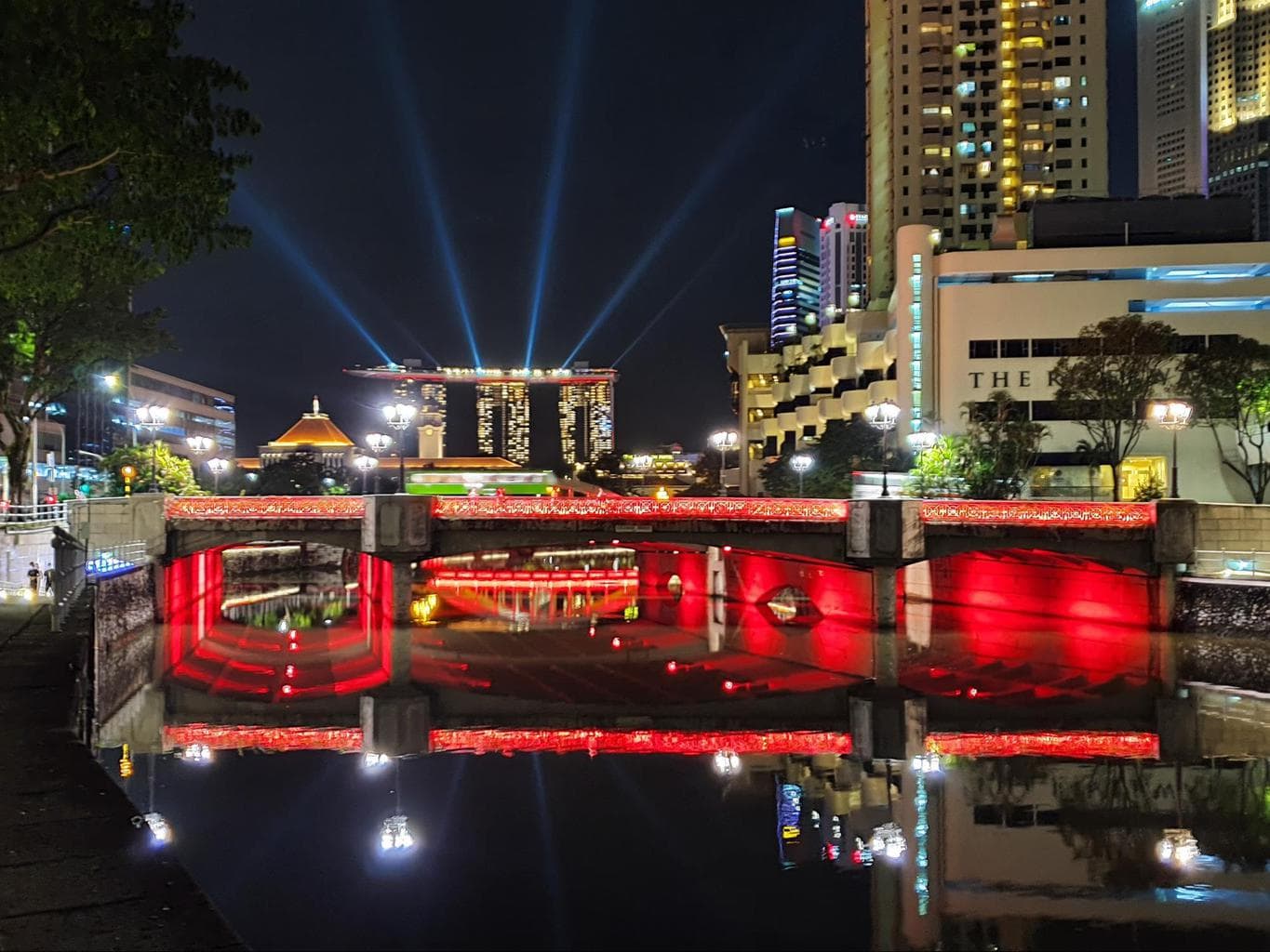
During your walk, spot the various bridges, the Parliament, the High Court house, the Asian Civilisations Museum (ACM), the picturesque Clarke Quay covered area and the Singapore River cruises. Remember to look back towards the Marina, the views of Marina Bay Sands are great.
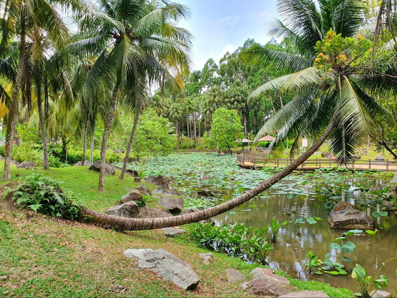
Bishan Ang Mo Kio Park – 6km

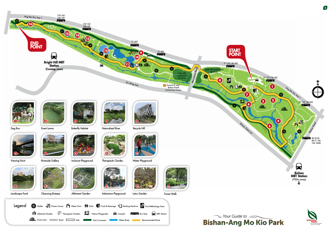
This park in the middle of a largely residential area provides a respite from the surrounding traffic and is very pleasant with all the water features, streams and ponds. There are also several resting areas with benches to read a book under the shade.
Kids will enjoy the park’s water playground and adults can look out for the steel structure “An Enclosure For A Swing” or check out the Therapeutic Garden. We particularly loved the Lotus Garden which is a perfect spot for a break.
Take a detour from the park to visit Kong Meng San Phor Kark See Monastery or connect with MacRitchie Reservoir or Lower Peirce Reservoir Park to make it a day.
Jurassic Mile + Changi Airport Connector – 8km

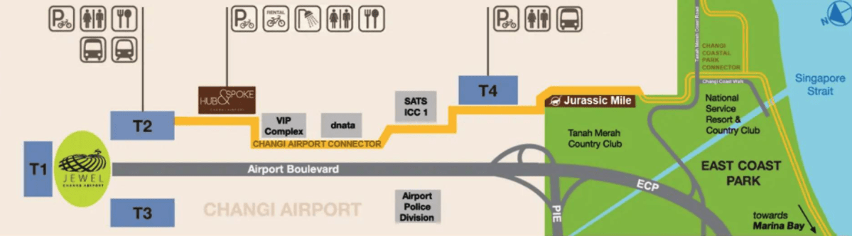
Cyclists and hikers can finally go all the way to East Coast Park (ECP) via the Changi Airport Connector which connects Changi Airport to ECP. There is a pathway where the public can walk or cycle and right at the very end of the Connector is a short trail where you can explore the dinosaurs at scale, known as the Jurassic Mile.
The new 4km Changi Airport Connector begins at Terminal 2 and links it to Terminal 4 and on to East Coast Park. The addition of this route means that you can cycle or hike from mostly anywhere in Singapore, it even connects with the Eastern Coastal Loop for a trip to camping favorite Pasir Ris of East Coast Park (Changi Beach Park is roughly 12km away from the end of Jurassic Mile).
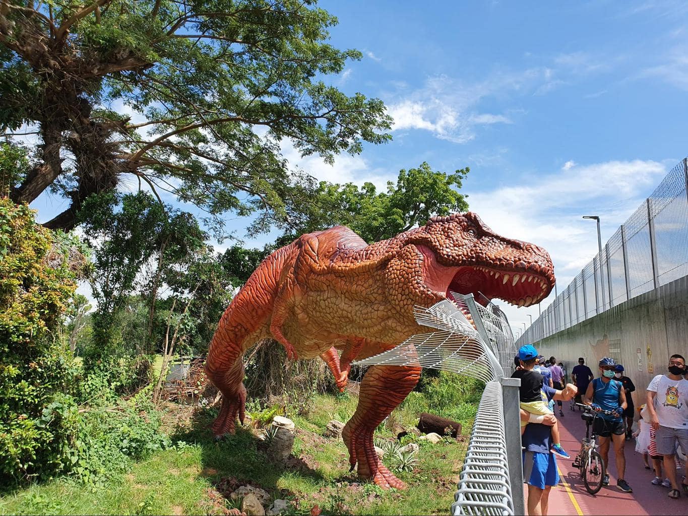
Jurassic Mile starts at the parking lot of Changi Terminal 4 and stretches for 1km (not a mile) along the perimeter of the airport. There is a walking path sandwiched between the airport’s Terminal 4 and the Tanah Merah Golf Club that is themed after the Jurassic Park book and movie franchise and has various exhibits showing famous dinosaurs.
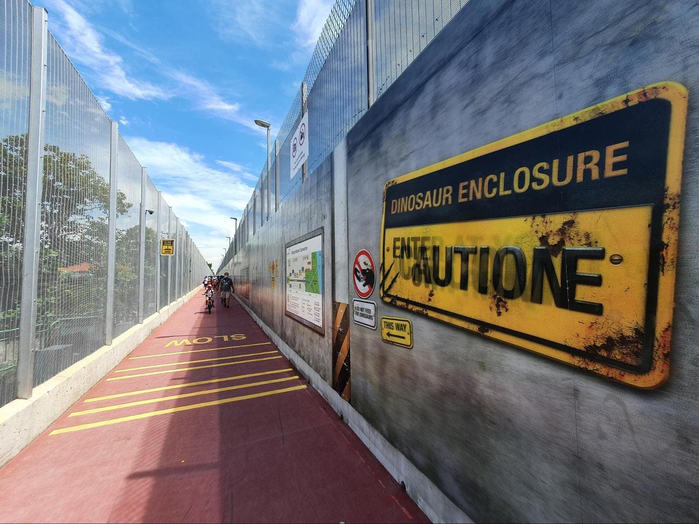
The Mile is open 24/7, but you will need to book a spot in advance, as they need to manage crowds and visitor numbers on Friday, Saturday and Sunday from 9am to midnight. This is expected to be the case until at least January 2021. It’s fun and interactive, but it must be known that you cannot cycle it due to its narrow size. You can either leave your bike at the lockers or walk it through.
You can start near the Terminal 4 parking lot, which is connected to Terminal 2, Instagrammable Jewel and the MRT via the Changi Airport Connector, but not so well connected at the other end. This means that you’ll need to walk back or call a taxi at the end of the trail as there is nothing other than the wide and heavily trafficked industrial Tanah Merah Coastal Road, and East Coast Park a few kms away on a concrete path.
Expect a very easy and doable 30-45min return walk, even with kids, starting and ending at Terminal 4. The full walk back to T2, Jewel and the MRT is about 8km. If you are catching a Grab, place the destination as T4 and ask the driver to drop you at the entrance of Carpark 4A.
Southern Ridges – 10km

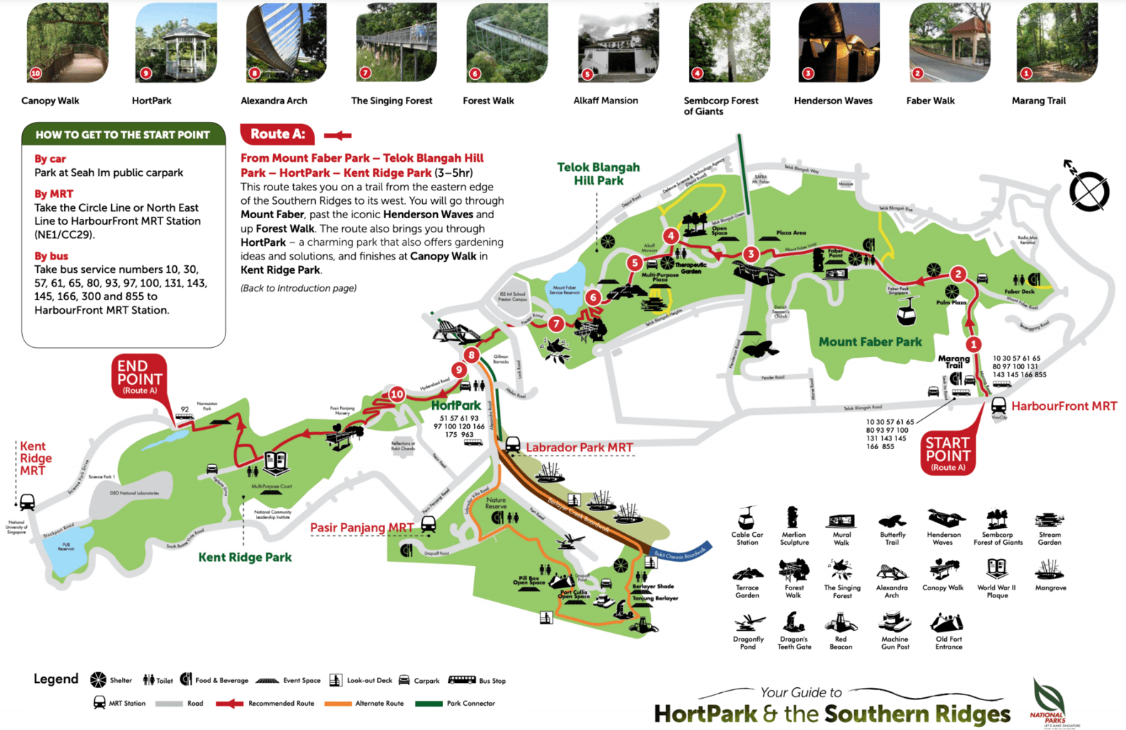
Start at Harbourfront MRT and finish at Kent Ridge MRT for the complete 4-park, 10km trail that crosses some of the best hiking paths in Singapore, in complete nature at times, with great sea views and along some of the most trafficked roads.
We love this hiking trail because it has elevated canopy walks, the scenic Henderson Waves bridge, lots of hilltop views, gardens and tall trees. There are some ups and downs, with short steep climbs followed by long slow descents.
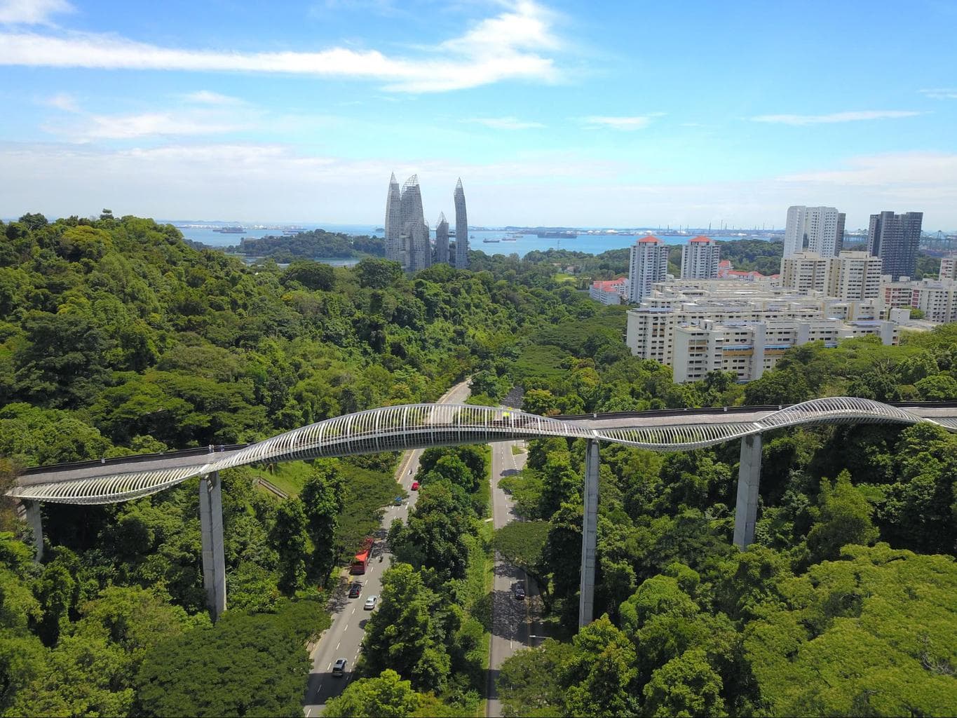
Start at Mount Faber Park where you can enjoy a brunch with views over Sentosa and even a return cable car ride if you wish, then continue towards Telok Blangah Hill Park where you will also have the chance to enjoy the metal canopy Forest Walk, then cross the Alexandra Arch bridge to reach HortPark and finally end at Kent Ridge Park.
This hiking trail gives you the chance to see lots of trees and birds, especially in the singing forest, which is made of trees that attract over 200 species of birds.
You can connect this trail with Labrador Park which you can divert to after Telok Blangah, instead of HortPark and Kent Ridge Park. Here is our complete guide to the Southern Ridges and Henderson Waves which includes a suggested itinerary, an interactive map and more in-depth information on each of the stops.
Marina Bay Loop – 11km

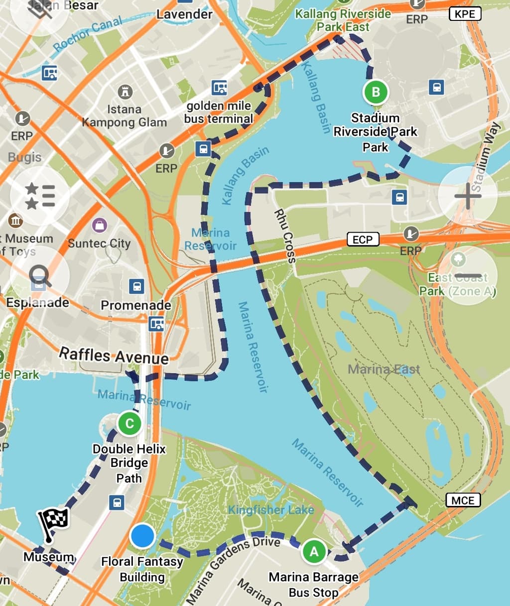
This trail is our own making and one that we love to take. Start at the Floral Fantasy at Gardens by the Bay and then continue towards the Marina Barrage, bordering the Supertrees. Cross over to the other side of the Gardens by the Bay, follow the water’s edge until you reach the ECP bridge, cross it underneath and head towards the Stadium.
You will walk past the Stadium, and look for the Kallang Riverside Park East until you can cross the river to the other side of the kallang basin and then continue towards the F1 Pit Building and the Singapore Flyer. Then take the Helix Bridge and reach the Shoppes.
The last stretch follows the scenic pedestrian area in front of the Marina Bay Shoppes, ArtScience Museum and all the dining outlets and ends at the Red Dot Museum. You could continue by circling around the Marina, heading towards the Customs House, One Fullerton and the Merlion and end at Esplanade.
While this is a long trail, it is a very easy one because it is paved, marked and flat in its entirety, but I love it because it’s full of flowers and great views. It’s also a nice trail to do in Singapore when it rains as you’re always near a covered area if it starts to pour. It is also an amazing Singapore hike to take at night. Be sure to time your trip so that you can see Garden Rhapsody, the Gardens by the Bay Light Show which has two performances at 7:45pm & 8:45pm daily.
MacRitchie Lornie Trail + Treetop Walk – 14km
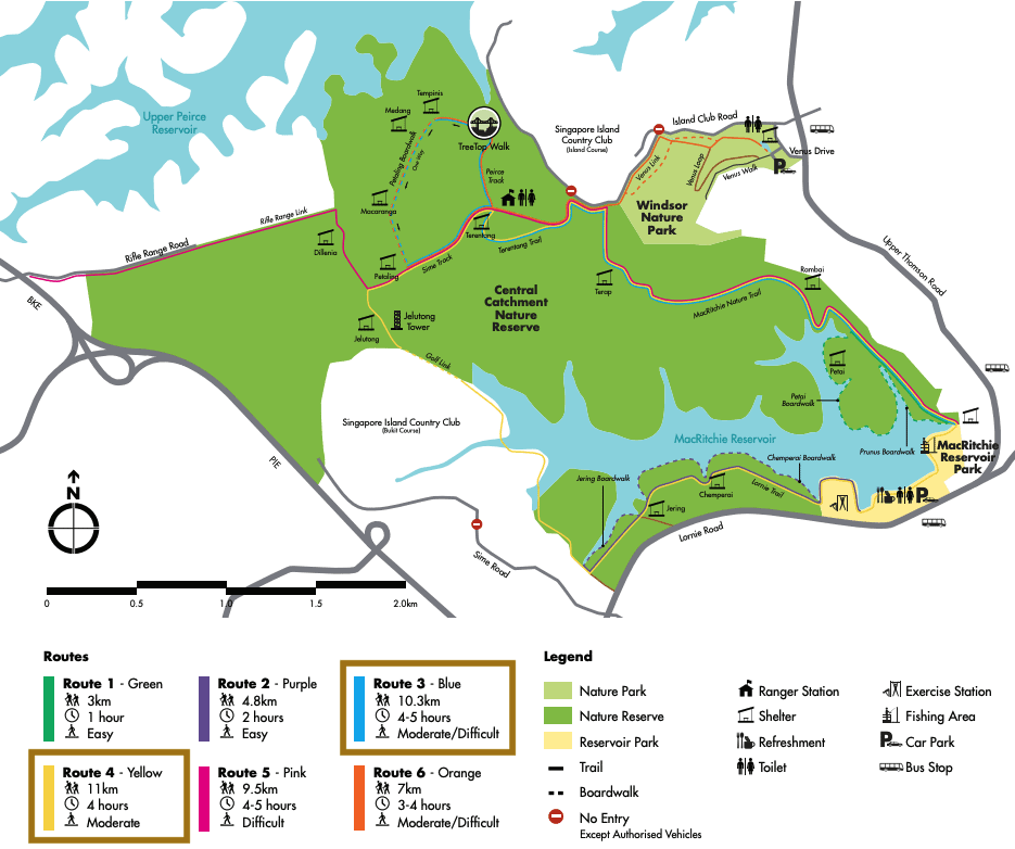
This trail in MacRitchie combines the moderately difficult (for Singapore standards) yellow Lornie Trail which covers 11km with the blue Treetop Walk trail which overlaps for the most part except for the Treetop loop section which is quite steep and has a lot of steps. Together, the trail is about 14km long and will take you around 4h to complete.
We love this trail because it combines a lot of what makes MacRitchie a great park, and we like to start going towards the Treetop first and then finish off with a part of the boardwalk Chemperai trail instead of walking along the regular parth (take the dotted purple trail instead of the yellow bit towards the end). Note that the Treetop Walk is closed until May 2021.
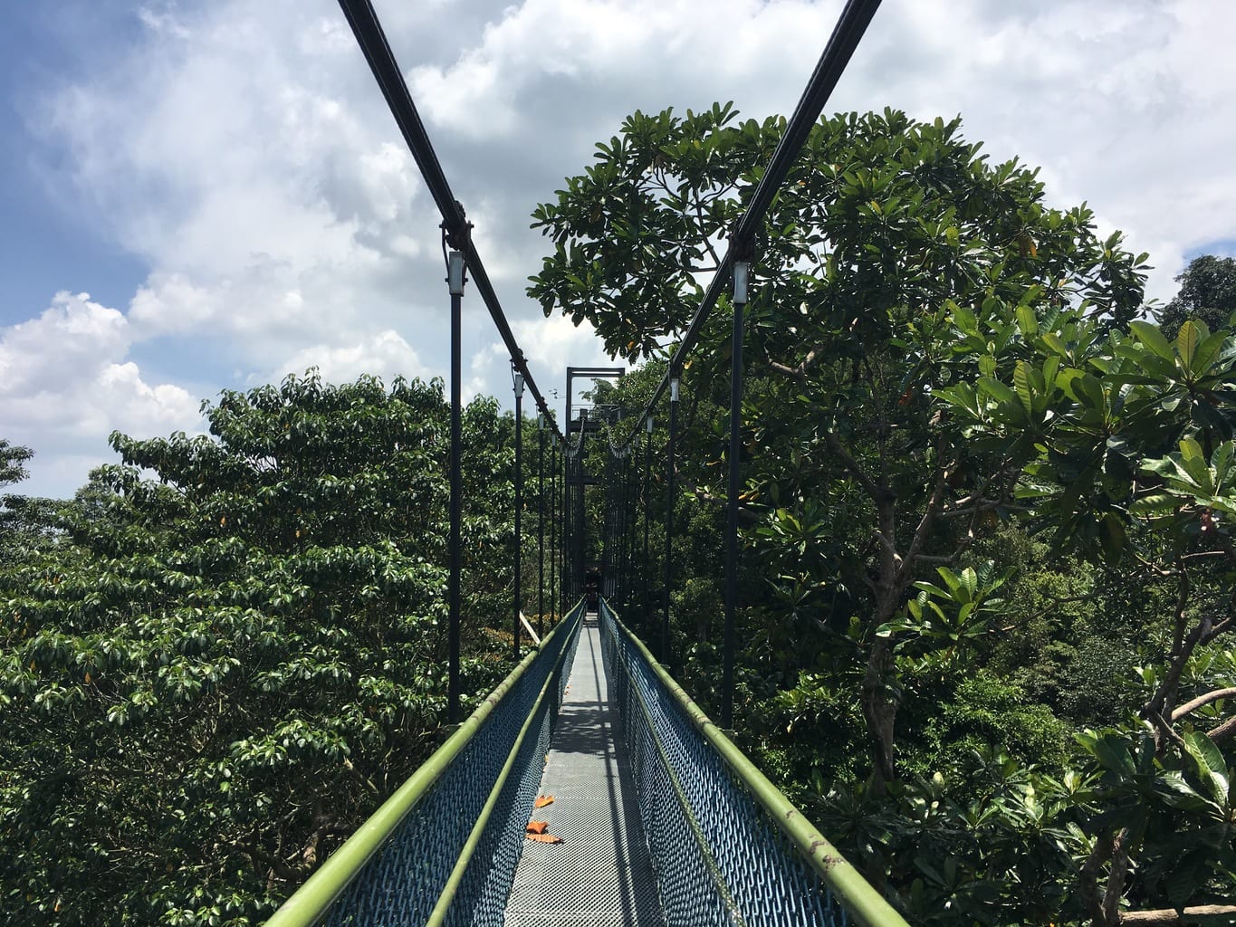
You will walk through flat parts, steep hills, wooden steps, waterside boardwalks, gravel paths, forested areas, canopy tops, golf greenery and lots of bird-chirping peacefulness. MacRitchie’s rawness is what makes it such a great hiking trail in Singapore.
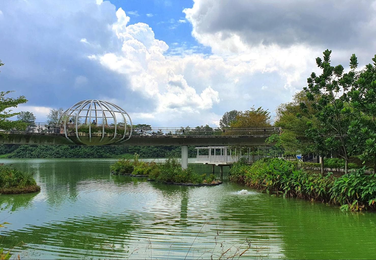
Northeastern Riverine Loop – 16km

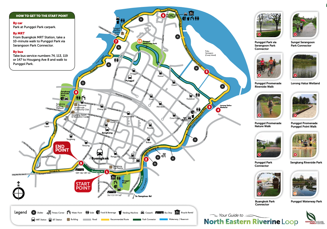
This wonderful cycling route is also a great hiking and walking trail in Singapore that you can enjoy on a long day walk. The North Eastern Riverine Loop is located in Punggol which many see as “too far away”, but trust us exploring it is a delight, especially for cyclists, runners and nature lovers.
It’s a 26km route that connects several green locations in Singapore including Punggol Park, Punggol Waterway Park, Punggol Point Park, Sungei Pinang/Serangoon Park Connector, Lorong Halus Wetland, Marina Country Club, @Punggol, Riverside Walk, The Punggol Settlement, Punggol Ranch and Sengkang Riverside Park. It’s a gorgeous route with over 80% of it running parallel to waterways and reservoirs. This means plenty of wildlife, with sea otters, herons and horses.

Although the entire loop takes around 3-4 hours to walk or 2 hours to bike, you can actually spend an entire day exploring it. You can start the Loop in the South (Sungei Pinang) or North (Coney Island West Entrance where the Nature Walk begins) or somewhere in the middle (Punggol Park).
The simplest option is starting at Punggol Park which has a parking lot, is a 10min walk fromBuangkok MRT via the Serangoon Park Connector or a quick walk from the bus stop at Hougang Avenue 8.
Find out more on the NParks guide or see our North Eastern Riverine Loop itinerary and guide.
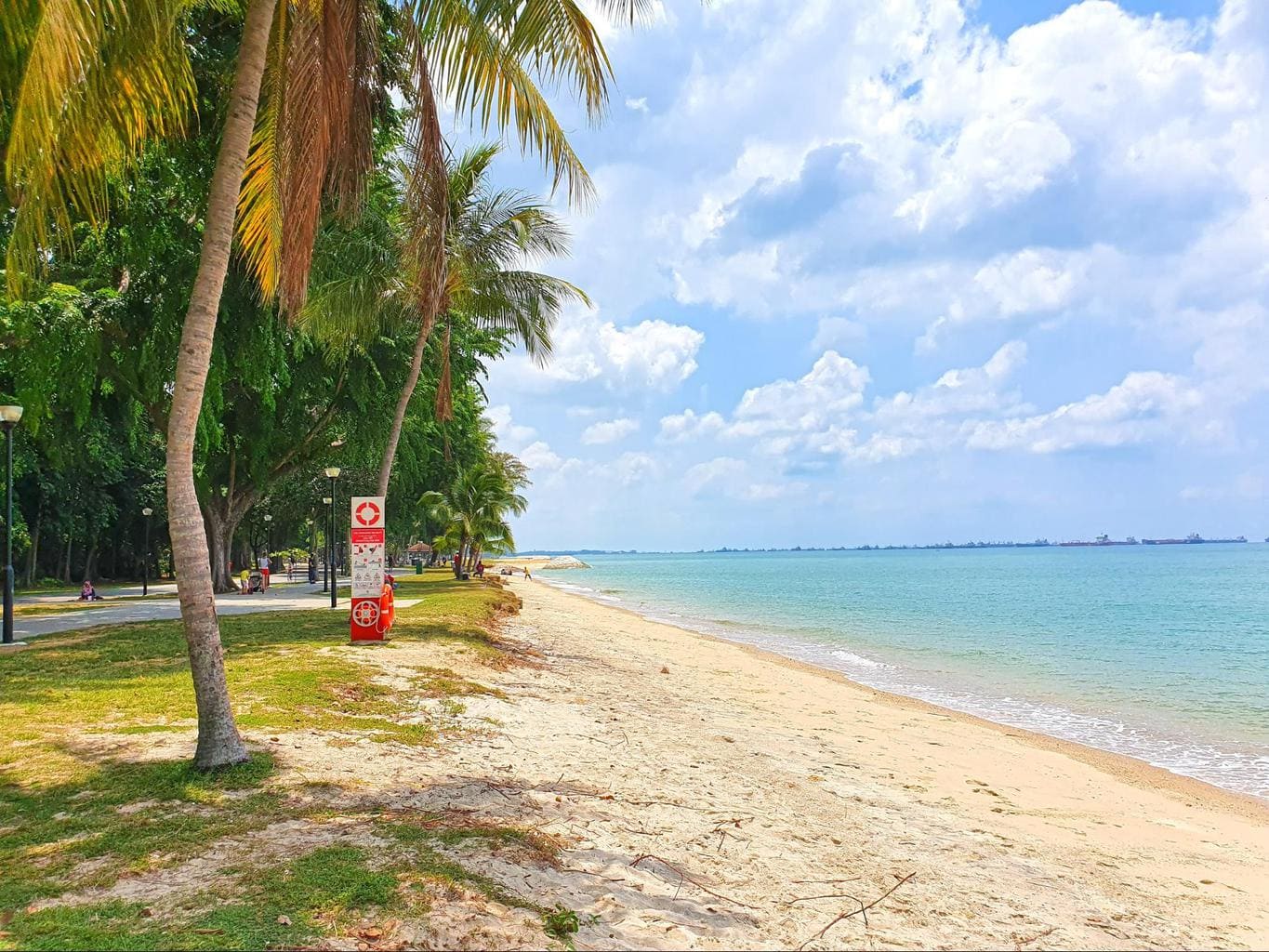
East Coast Park – 14km

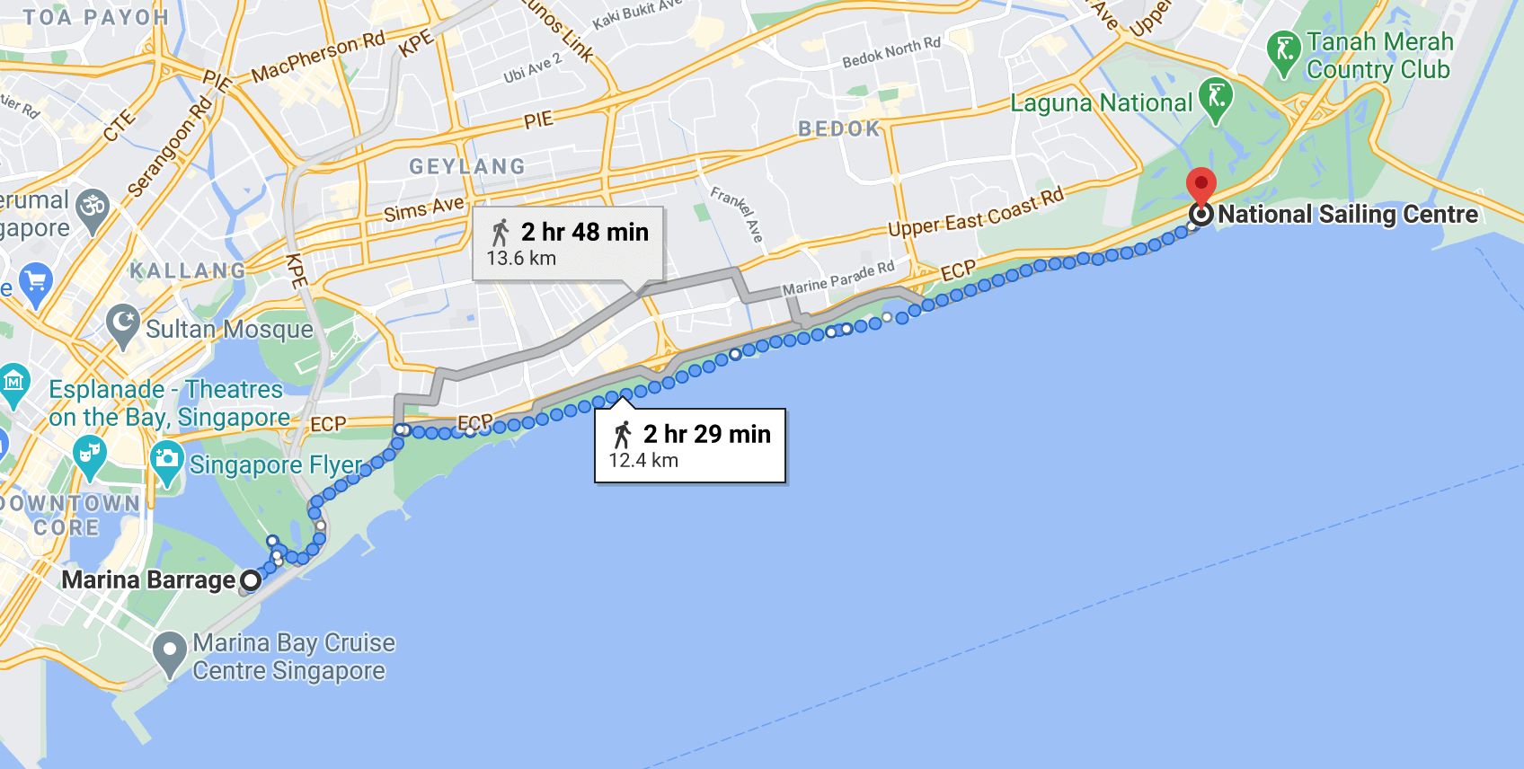
East Coast Park is the most popular park in Singapore and with reason. It has a lot of activity spots for kids and grown ups and it runs along the beach which makes it a perfect spot to take a bit of a break from the tall buildings. There is also quite a bit of shade along the way so you don’t get cooked by the strong sun rays.
The entire walk from Marina Barrage to the Sailing Club will cover a distance of approximately 14km all of which are flat with the exception of a bridge when you leave the Gardens by the Bay area and enter ECP.
That means this is a relatively easy walking trail in Singapore. Plus every time you need a break you are sure to find a bench, a grassy spot, a pavilion or even a cafe.
East Coast Park is packed with amenities and facilities. There are playgrounds for children, cafes galore and even a hawker centre where you can renew all your energy.
Pro tip: ECP can get really crowded on the weekends and some parts, during the weekday evenings, but it is almost empty during weekdays in the morning so if you can flip your schedule, you’ll find the park all to yourself.
Eastern Coastal Loop – 17km

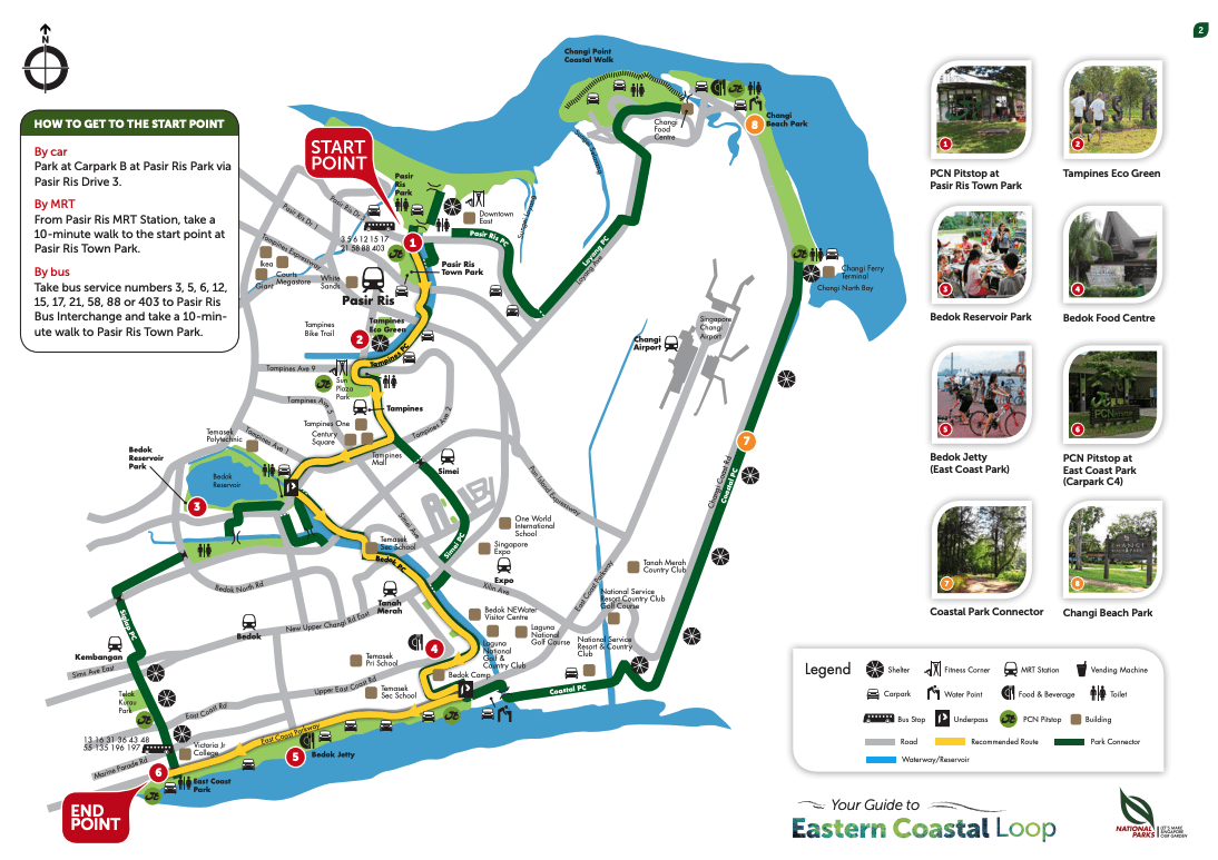
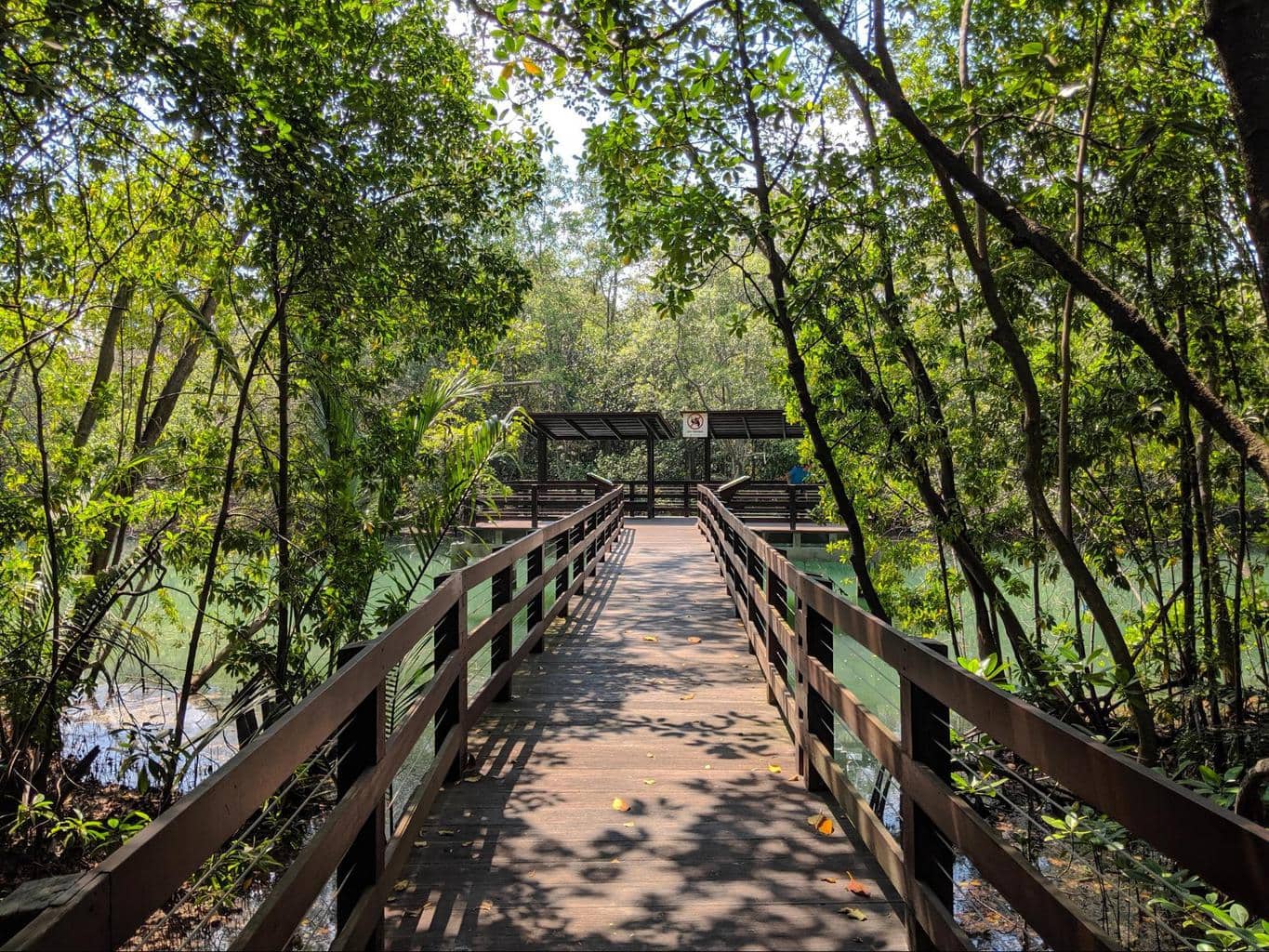
Going from Pasir Ris to the East Coast, this hiking trail is quite nice and combines a walk along most of the East Coast park with the mangroves of Pasir Ris and the Bedok Reservoir.
We recommend that you start exploring Pasir Ris before starting the hike, maybe even enjoy a nice breakfast with sea views or at the Pasir Ris Town Center. The mangroves are the second largest after Sungei Buloh and the park has a small but fun maze.
Pro tip: Consider taking a detour and adding Jurassic Mile (though that would be another 10km), if you have the time and stamina.
Pasir Ris mangroves
The trail also explored Bedok Reservoir where there are lots of activities to keep you busy or where you can take a break, and East Coast Park that makes for a great pit stop for lunch. Check out our previous hiking trails here for details on East Coast Park.
Coast to Coast trail – 32km

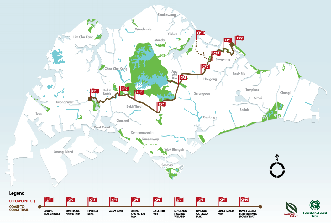
This 32km Coast to Coast trail will take you from Jurong Lake Gardens all the way to Lower Seletar Reservoir Park in what is a great day of exploration.
Expect the trail to take you an entire day, usually 8-9h plus breaks to eat, rest or enjoy the sightseeing.
Beyond the length, the trail is relatively easy as it mostly crosses flat land and paved roads, so it’s more about the stamina to make it through a long hot day than the physical fitness to go uphill.
The Coast to Coast trail has 10 checkpoints for you to stop at and enjoy with panels designed to give you more background and tips for sightseeing.
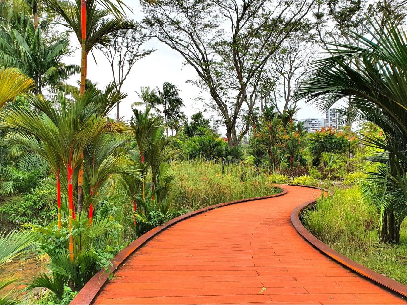
You will start at Jurong Lake Gardens, then head to Bukit Batok Nature Park, Hindhede Drive, which is adjacent to Bukit Timah Nature Reserve (and does not enter Bukit Timah), then continue along scenic Adam Road, the Botanic Gardens, Marimont Road, Bishan Ang Mo Kio Park, Luxus Hills Park, Sengkang Floating Wetland, Punggol Waterway Park, Coney Island and finally, Lower Seletar Reservoir Park.
Besides the maps that you will find at the various checkpoints and the one provided by NParks there is also an App that you can use which contains all the information from the checkpoints as well as the route, although it isn’t interactive, so you won’t know where you are in the trail. For that, use Google Maps.
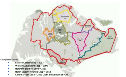
Central Urban Loop – 36km

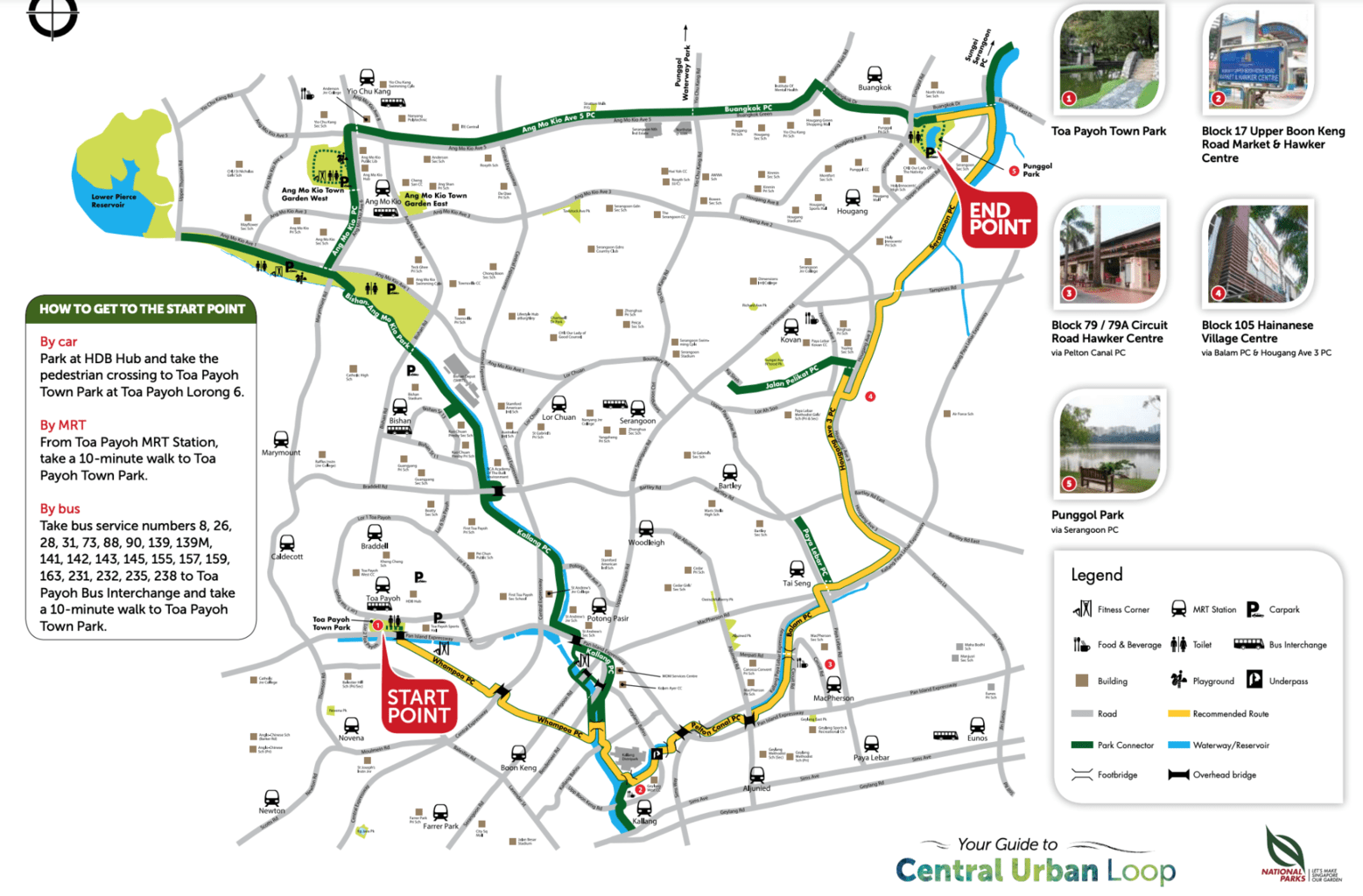
The Park Connector Network has a few trails that are mostly thought out for runners and cyclists but which also make for great hiking trails in Singapore. The Central Urban Loop will take you the best part of a day and offers a huge array of options.
Like the Coast to Coast trail, this one crosses several estates and neighborhoods in Singapore and walks past big parts of the country’s heartlands, from Kallang to Toa Payoh, Whampoa and Punggol.
You will start at Toa Payoh Town Park and walk along the canals and rivers until you hit the concrete jungle and end at Punggol Park.
From there, you could continue through an additional stretch of the Park Connector Network towards Lorong Buangkok, Singapore’s last remaining kampong, and have the option to merge with the Northeastern Riverine Loop, though you should add another 4-5h for it making the total time requirement near 12h.
Round Island Route – 150km

Are you up for a real challenge? Why not walk the entire perimeter of Singapore along the soon-to-be-completed Round Island Route.
Follow in the footsteps of two writers from Channel News Asia who completed 142km of the route in October 2020 over 5 days and explore every corner of Singapore. The 150km mostly cycling path takes on the entire island and will be completed in 2022.
In the meantime, you may have to take a few detours. By the end of 2020, 60km of the route connecting Rower’s Bay with Gardens by the Bay will be completed and the remaining 60km to make the 120km loop will be finished in 2021.